

Street numbering in Oxford
Beware: There is no certainty that street numbers given in Kelly's Directory will match those of today (in some cases even as late as the 1950s). To add to the problem, some streets changed their numbering system twice.
There are two ways to match the houses whose numbers have changed:
- Compare the last Kelly's Directory that has the old numbers with the first directory that has the new ones.
- Compare the censuses before and after the number change (remembering that even quite small streets can fall into more than one parish and will therefore be found in more than one census book)
Here are some examples of nineteenth- and twentieth-century century number changes. Note that many streets have also changed their names:
OxfordBanbury Road (south end, including what was St Giles' Road East) Cowley Road: North side and South side Merton Street (which kept the original numbering from west to east, but then Museum Road (formerly Museum Terrace) Park Town (formerly Park Crescent/Clarendon Villas/Park Terrace) St Michael's Street (formerly part of New Inn Hall Street) Turl Street (partly renumbered in the early 1880s) Walton Street (the SW section that was formerly Walton Place) Woodstock Road (south end, including what was St Giles' Road West) |
HeadingtonBarton Village Road (formerly The Village, Barton Road) Holyoake Road (formerly Western Road) Old Road (formerly Shotover Road and Old Road) Old High Street (formerly High Street, Old Headington) Osler Road (formerly Manor Road, Headington) |
Cowley Road appears to have the same numbering today as it did at the time of the 1921 census.
Identifying houses from 1772 to 1837
The streets of central Oxford underwent many improvements and changes as a result of the Oxford Mileways Act of 1771. Identifying houses in central Oxford just after that date is made easier thanks to H. E. Salter's list of the houses in his Survey of Oxford taken in 1772.
Until about 1836, however, it appears that many streets of Oxford had no organized numbering system. This was true of most streets in England that had grown organically; the only houses to have numbers before the 1830s were likely to be in terraces (as in Bath) that were built completely afresh.
People would thus find their way by directions such as “Two doors to the right of the Angel”. This would have worked well in central Oxford, as its old streets were punctuated at regular intervals not only by shops, and inns and pubs, but by colleges and university buildings.
At least four of Oxford streets do appear to have had an earlier numbering system, but it does not appear to have been consistently used and does not always match the numbers of today:
- Cornmarket Street: On 24 March 1827 the linen draper John Breakspear announced in Jackson's Oxford Journal that he was closing his shop at 65 Cornmarket, and on 12 May 1827 C. Shillingford advertised that his grocery & tea warehouse was at No. 65. On 6 October 1827 Joseph J. Hemmings advertised his sausages at No. 4 and on 10 October 1829 T. & J. Greatbatch announced that they had opened a glass & china warehouse at 60 Cornmarket Street, and both of these matches today's numbering. On 3 April 1830 the hairdresser G. Goodwyn said he had taken over Mr Cox's premises at 34 Cornmarket “nearly opposite St Michael's Church”, which almost matches the current numbering, and on 23 February 1833 Messrs Preedy, grocers, announced that they had taken over the premises of Messrs Gee & Warton at 58 Cornmarket.
- Holywell Street: there are traces left of a pre-1830s numbering scheme on some of the houses
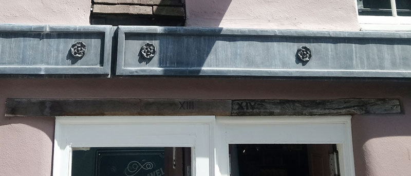
- New Inn Hall Street: there are signs of a pre-1830s numbering system on the wooden lintels over the two doors of the present 22 New Inn Hall Street (Morton's Café). The photograph below shows the house on the left numbered XIII (13) and the one on the right XIV (14). This shows that the east side of the present New Inn Hall Street must have been numbered from north to south at this point, although it is hard to see how the numbering worked, as it should have started at Cornmarket on the south side of the present St Michael Street (see this page for an explanation of why that street used to be New Inn Hall Street).
- High Street: The numbers in the early 1830s appear to have been much the same as today. Richard Spiers the hairdresser, for example, stated in Jackson's Oxford Journal on 13 October 1832 that he was at 28 High Street and the draper Edward Bartlett on 20 April 1833 that he was at 14 High Street. J. Shayler's City & County Emporium was advertised at No. 114 on 22 March 1834, and Cruse Horn's hairdressing shop at No.141 on 8 October 1836.
Holywell Street was renumbered in the autumn of 1837, and is likely that Cornmarket and New Inn Hall Street were also renumbered at this time, while other streets in the city such as Broad Street appear to have been allocated numbers for the first time.
Late 1830s to mid-1880s
The Paving Commissioners secured powers to set up names of streets and numbers on houses in Oxford by an Act of Parliament (5 & 6 William IV (1835–6), c. 69, pp. 41–2).
Robson’s Commercial Directory of 1839 is the first directory of Oxford to show numbered houses, and the inauguration of the Penny Post the following year must have precipitated almost universal numbering of city streets in England. Villages however managed without numbers until the twentieth century, however, and some houses continued with house-names instead of numbers until the 1960s. The first census when houses in Headington, for example, were listed with proper addresses was in 1921. .
From the 1830s to the mid-1880s, houses in England were numbered continuously, with 1, 2, 3 etc. from the main junction of a street to the end, with the numbering being picked up on the other side of the road and continuing back to the starting end. This means that the lowest and highest numbers would always be opposite each other: for instance, in Oxford’s High Street, Lloyd’s Bank at No. 1 faces the Edinburgh Wool Mill shop at No 143.
Most of the pre-1880 streets of Oxford are still burdened with this old numbering system, which makes it impossible to estimate from the number where the house is. The other big disadvantage of the system is that when a long road such as the Cowley road that had originally only been developed at the city end expanded further outwards, there were no logical numbers that could be used for the new houses.
Hunt’s Oxford Directory for 1846 shows that most of the streets of central Oxford had the same numbers then as they do today, give or take a bit of infilling. Besides the High, the other Oxford streets which still have this old-fashioned numbering system include Beaumont Street, Broad Street, Cornmarket Street, King Edward Street, Magdalen Street, New Road, Pembroke Street, Queen Street, St Giles, and Turl Street, as well as most of the streets of the old dense suburbs of East Oxford and Jericho (including Walton Street itself).
The Town Improvement Clauses Act of 1847 covered street numbering as follows in Clauses 64 and 65:
64. Houses to be numbered and streets named.
The commissioners shall from time to time cause the houses and buildings in all or any of the streets to be marked with numbers as they think fit, and shall cause to be put up or painted on a conspicuous part of some house, building, or place, at or near each end, corner, or entrance of every such street, the name by which such street is to be known; and every person who destroys, pulls down, or defaces any such number or name, or puts up any number or name different from the number or name put up by the commissioners, shall be liable to a penalty not exceeding £25 for every such offence.
65. Numbers of houses to be renewed by occupiers.
The occupiers of houses and other buildings in the streets shall mark their houses with such numbers as the commissioners approve of, and shall renew such numbers as often as they become obliterated or defaced; and every such occupier who fails, within one week after notice for that purpose from the commissioners, to mark his house with a number approved of by the commissioners, or to renew such number when obliterated, shall be liable to a penalty not exceeding £20, and the commissioners shall cause such numbers to be marked or to be renewed, as the case may require, and the expence thereof shall be repaid to them by such occupier, and shall be recoverable as damages.
Jackson's Oxford Journal of 21 August 1858 reported:
NUMBERING OF THE HOUSES IN OXFORD.—We understand that in consequence of the complaints which have been made on the subject, the Street Commissioners are turning their attention towards a better system of numbering the houses in those streets where at present there is no uniformity, but, on the contrary, several numbers alike. They have agreed to commence in St Aldate's-street, and to start from Plowman's Agricultural and General Agency Office, on the left-hand side, and to number the houses consecutively as far as Folly Bridge, when the numbers will be continued on the opposite, or right-hand side, back to Carfax.
The forthcoming 1871 census motivated the rationalization of street numbering: Jackson's Oxford Journal of 4 March 1871 stated that the Chairman of the Oxford Local Board “reported that the numbering of houses in the town was being rapidly proceeded with, in compliance with a request from the Registrar-General, in order to facilitate the labours of the collectors of the next census returns”.
One reason for renumbering a street was the addition of new houses. Here Jackson's Oxford Journal of 6 February 1886 reports how the General Purposes Committee decided to postpone the knotty problem of renumbering the Iffley Road:
Nine new houses having recently been built on the north-east side of Iffley-road, near the Cape of Good Hope, it appears necessary that they should be numbered, but as this would involve the re-numbering of the whole of the Iffley-road, which would probably cause inconvenience to the occupiers, the Committee have postponed the matter for the present, in order that the views of the inhabitants might be ascertained.
It took about another six years before the Iffley Road was renumbered as it is today.
1880s to present
In the 1880s, a new, more practical, method of numbering new houses was implemented. This put odd numbers on one side of the road and even numbers on the other (starting in both cases with the lowest numbers at the main junction of the road). This means that without any prior knowledge whatsoever, anyone can deduce from a map roughly where a number will fall in a street.
Usually the odd numbers are on the left and the even ones on the right as you stand at the end with the lowest numbers, but there are exceptions, e.g. Sandfield Road in Headington.
When the odds and evens system was introduced, it was primarily just used in Oxford for newly built streets (e.g. Boulter Street, Marlborough Road, and Walton Well Road). A few roads which had not had time to settle into the old numbering system were renumbered (e.g. Plantation Road and Catherine Street by 1887, and Norham Gardens by 1889), but on the whole the numbering of the old streets was left in the old consecutive system.
If streets had to be renumbered because of infilling, however, the new system was used. In November 1886 it was agreed that the Banbury Road should be renumbered, and this extract from the General Purposes Committee report published in Jackson's Oxford Journal on 9 April 1887 shows that householders were obliged to fix the new numbers to their doors:
That notice be served upon Mr. E. Ryman Hall, requiring him to affix the number “37” to the door of his house in Banbury-road, and that a like notice be served upon Mrs. Filsell requiring her to affix the number “50” to her house, this being necessary in order to complete the arrangement for re-numbering the road, which was agreed to by the Board in November last
The Woodstock Road was also renumbered under the new system at about this time. This does not mean, however, that the numbers henceforth remained static: subsequent infilling sometimes made further renumbering of some roads necessary.
Other streets which once had widely spaced houses with swathes of spare land have been subject to so much infilling that renumbering became essential between the 1930s and the 1950s. Hence the Marston Road (greatly infilled) has the modern style of numbering, while Marston Street (where the houses are terraced and could not be breached) the old. And in central Oxford, George Street was renumbered in 1895/6 when the building of the Old Fire Station and the Corn Exchange knocked a hole in the old numbering system.
As for the outlying villages that became suburbs of Oxford in the twentieth century, numbering there was treated summarily by the city. When Headington and Cowley became part of Oxford in 1929, their old-fashioned numbering system was generally modernized in one fell swoop.
Warning: Numbers of developing roads often changed more than once, sometimes only a few years after the previous change
Complications caused by the City Wall
Two streets in Oxford had names and numbering which were quite logical when the city wall was in place, but survived long after the wall had disappeared:
- New Inn Hall Street. When this hit the city wall, it did a sharp right turn into what is now St Michael Street. It was eventually extended up to George Street in 1872, and it was only in about 1900 that St Michael Street came into existence: full details
- Catte Street only ran north as far as the city wall, so came to an end roughly where New College Lane is now. The seven shops and houses later built to the north of the site of the city wall on the east side were therefore numbered 28–34 Broad Street and regarded as being in Broad Street east
Below: The three-times-numbered Iffley Road photographed by Henry Taunt when it started to be build up
(Historic England CC54/00309)